CMCC Mediterranean Analysis and Forecasting system MedFS
CMCC develops and implements a numerical ocean prediction system that produces analysis and short term (10 days) forecasts for the entire Mediterranean Sea and its Atlantic ocean adjacent area.
![Figure 1: Mediterranean Sea numerical domain and bathymetry [m].](../imgs/medsea-bath.png)
SHORT DESCRIPTION
The Mediterranean Analysis and Forecasting System (MedFS) became operational in the late 90’s and was developed in the VI and VII EU and National Framework programs (Pinardi et al., 2003, Pinardi and Coppini 2010, Tonani et al. 2014) and since 2015 is part of the Copernicus Marine Service. MedFS is developed and operationally maintained at CMCC since 2018 (Coppini et al. 2023) providing regular and systematic information about the physical state of the Mediterranean Sea. The service is available 24 hours a day, 365 days a year.
MedFS is a coupled hydrodynamic-wave modeling system with data assimilation component (OceanVar) based on the Nucleus for European Modelling of the Ocean (NEMO) producing the hydrodynamic fields and the third-generation wave model WaveWatch-III (WWIII) providing the wave component. Ocean measurements from satellite altimeters (SLA) and in situ temperature and salinity vertical profiles (ARGO, Gliders, CTD and XBT) are assimilated and a nudging to the satellite sea surface temperature (SST) is performed.
The model is forced with high resolution ECMWF (European Centre for Medium-Range Weather Forecasts) atmospheric fields and is nested in the Atlantic Ocean through the Copernicus global ocean analyses and forecasting system.
The analysis is produced once a week (on Tuesday) for the previous 2 weeks, while each day the system produces 10 days forecasts.
- MedFS-EAS1: 1/16˚ horizontal grid resolution and 72 vertical levels (Clementi et al., 2016)
- MedFS-EAS5: 1/24˚ horizontal grid resolution and 141 spaced vertical levels (Clementi et al., 2019)
- MedFS-EAS10: 1/24˚ horizontal grid resolution and 141 spaced vertical levels including tides
MedFS-EAS10 is the actual operational system delivered through the Copernicus Marine Service and the Analysis and Forecast product (MEDSEA_ANALYSISFORECAST_PHY_006_013) is available through the Copernicus Marine Catalogue.
All operational systems produce monthly, daily and hourly 3D temperature, salinity, currents and 2D sea surface height, mixed layer depth and bottom temperature.
MedFS systems major characteristics and evolutions
| MedFS system | Model | Resolution | Start (initial) time | Time Step [sec] | Tides | N. River inputs | Lateral Open Boundaries | Atm. forcing | Data Assimilation | SST nudging |
|---|---|---|---|---|---|---|---|---|---|---|
| MedFS-EAS1 | NEMOv3.4 + WWIIIv3.14 + OceanVar |
H: 1/16˚ V: 72 z lev. |
12.00 UTC | 300 | No | 7 + Dardanelles strait: climatologies |
Atlantic box | ECMWF 1/8˚ | Dobricic and Pinardi (2008) SLA Barotropic Model: T/S profiles & SLA |
Whole day towards SST L4 |
| MedFS-EAS5 | NEMOv3.6-VVL + WWIIIv3.14 + OceanVar |
H: 1/24˚ V: 141 z* lev. |
00.00 UTC | 240 | No | 39: climatologies |
Atlantic box + Dardanelles strait |
From Dec 2020: ECMWF 1/10˚ |
Storto at al. (2015) SLA Dynamic Height T/S profiles & SLA |
Close to Midnight |
| MedFS-EAS10 | NEMOv4.2-VVL + WWIIIv6.07 + OceanVar |
H: 1/24˚ V: 141 z* lev. |
00.00 UTC | 180 | Yes: 8 components |
38: daily AN&FCST runoff from EFAS + Nile river climatology |
Atlantic box + Dardanelles strait |
ECMWF 1/10˚ | OceanVar2.0 (Oddo et al., 2026) SLA Barotropic model; T/S profiles(Med+Atl) & SLA(Med) |
Close to 05:00 a.m. |
The table shows major evolutions and modeling set-up changes between MedFS-EAS1, MedFS-EAS5 and MedFS-EAS10. Red text highlights the differences with respect to the previous system.
The hydrodynamic model NEMO
The hydrodynamic model NEMO (different model versions according to the system) has been implemented in the Mediterranean Sea using a non-linear explicit free surface formulation (MedFS-EAS5 and MedFS-EAS10 systems) solved by a time-splitting scheme. The last version of the system MedFS-EAS10 also includes the explicit representation of tides. It uses vertical partial cells to fit the bottom depth shape and a vertical time-varying z* coordinate system (MedFS-EAS5 and MedFS-EAS10).
The model is forced by momentum, water and heat fluxes interactively computed by bulk formulae using the 1/10° horizontal-resolution operational analysis and forecast fields from the European Centre for Medium-Range Weather Forecasts (ECMWF) at highest available time frequency (1 hour for the first 3 days of forecast, 3 hours for the following 3 days of forecast and 6 hours for the last 4 days of forecast and for the analysis). The water balance is computed as Evaporation minus Precipitation and Runoff. The evaporation is derived from the latent heat flux, precipitation is provided by ECMWF, while the runoff of a selected number of rivers (7 in MedFS-EAS1, 39 in MedFS-EAS5 and EAS10) is provided by daily mean analysis and forecast data from the European Flood Awareness System -EFAS in MedFS-EAS10 (monthly mean climatological data in MedFS-EAS1 and MedFS-EAS5). The model is nested in the Atlantic within the daily analysis and forecast CMEMS GLO-MFC product at 1/12° horizontal resolution, while the Dardanelles Strait boundary conditions are provided (in MedFS-EAS10) by the analysis and forecast CMEMS BLK-MFC product for the Marmara Sea dataset at 500m horizontal resolution (CMEMS GLO-MFC product for MedFS-EAS5) and the daily climatological values provided in Maderich et al. (2015). The topography is derived from the GEBCO 30arc-second grid filtered and manually modified in critical areas.
The wave model WWIII
The wave model WaveWatchIII (WWIII, different model versions according to the system) implemented in the Mediterranean Sea is forced by the same ECMWF atmospheric fields which force the hydrodynamic model. WWIII solves the wave action balance equation in slowly varying depth domain and currents considering a superposition of the following source/sink terms: wind input growing actions (based on Janssen’s quasi-linear theory of wind-wave generation: Janssen, 1989, 1991), a dissipation source term based on Hasselmann (1974) whitecapping theory according to Komen et al. (1984) and nonlinear resonant wave-wave interactions modelled using the Discrete Interaction Approximation (DIA, Hasselmann et al., 1985). The spectral discretization has been achieved through 30 frequency bins ranging from 0.05 Hz (20 s) to 0.79 Hz (1.25 s) and 24 equally distributed directional bins. The wave model takes into consideration the surface currents for wave refraction but assumes no interactions with the ocean bottom.
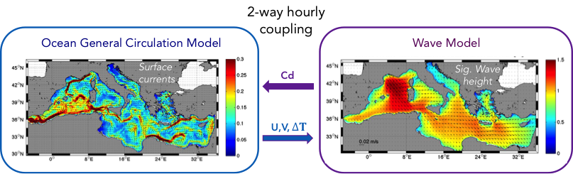
NEMO-WWIII coupling
The wave-current coupling is achieved as following:-NEMO provides every hour estimates of Air-Sea Temperature difference and Sea Surface Currents to WWIII, which returns back to NEMO the neutral component of the Surface Drag Coefficient (Figure 2) taking into account the wave induced effect at the air-sea interface (Clementi et al., 2017).
The OceanVar data assimilation
The data assimilation system of MedFS is based on a three-dimensional variational assimilation scheme (OceanVar for MedFS-EAS1 and MedFS-EAS5, and OceanVar2.0 for MedFS-EAS10), originally developed for the Mediterranean Sea by Dobricic and Pinardi (2008) and later extended by Oddo et al. (2026) implemented with a specific background error correlation matrix formulation.
The assimilated data includes: sea level anomaly (SLA) altimetry data, in-situ temperature profiles by VOS XBTs (Voluntary Observing Ship-eXpandable Bathythermograph), in-situ temperature and salinity profiles from ARGO floats, from Gliders (in MedFS-EAS10) and from different survey CTD profiles. In-situ profiles are assimilated in the Mediterranean Sea and (in MedFS-EAS10) in the Atlantic portion of the domain. Satellite objectively analysed Sea Surface Temperature (SST) is used for the correction of surface heat fluxes. All the assimilated observations are provided by the Copernicus Marine Thematic Assembly Centers.
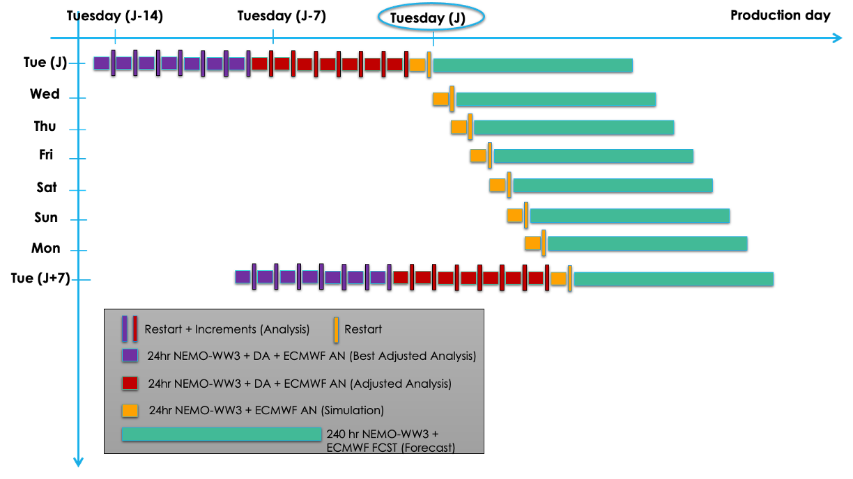
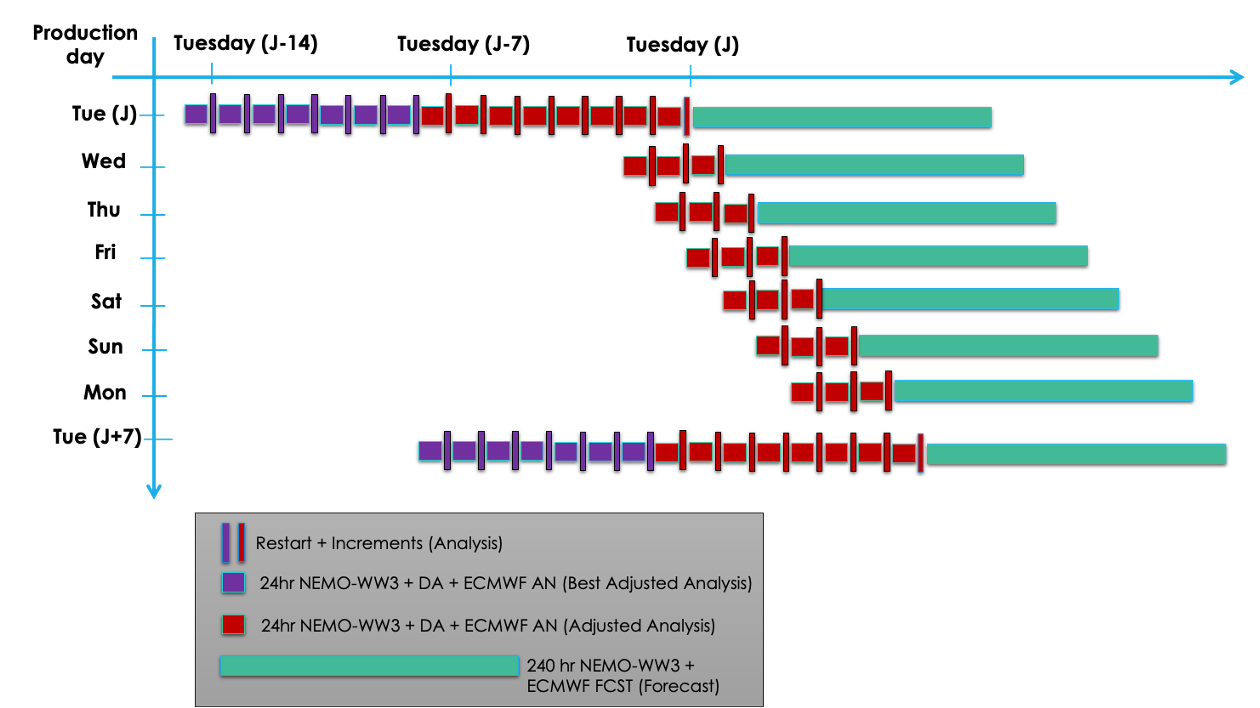
The MedFS processing chain
The MedFS processing system consists of two cycles: a daily cycle for the production of 3-days analysis (only for MedFS-EAS10) and 10-days forecast data, and a weekly cycle for the production of 14-days analysis data.
The analysis fields are produced with a daily assimilation cycle.
The 10-days daily forecast fields are produced every day and are initialized by a simulation for MedFS-EAS1 and EAS5, and by an analysis for MedFS-EAS10.
Sketches representing the production cycles are represented below.
Operational chain for:
MedFS-EAS1 & MedFS-EAS5
Operational chain for:
MedFS-EAS10
Essential references
- Clementi, E., Pistoia, J., Fratianni, C., Delrosso, D., Grandi, A., Drudi, M., Coppini, G., Lecci, R., Pinardi, N. 2016. Mediterranean Sea Analysis and Forecast (CMEMS MED-Currents 2013-2017) [Data set]. Copernicus Monitoring Environment Marine Service (CMEMS). https://doi.org/10.25423/MEDSEA_ANALYSIS_FORECAST_PHYS_006_001
- Clementi E., Oddo P., Drudi M., Pinardi N., Korres G. and Grandi A. (2017c). Coupling hydrodynamic and wave models: first step and sensitivity experiments in the Mediterranean Sea. Ocean Dynamics. DOI: https://doi.org/10.1007/s10236-017-1087-7.
- Clementi, E., Pistoia, J., Escudier, R., Delrosso, D., Drudi, M., Grandi, A.,Lecci R., Cretí S., Ciliberti S., Coppini G., Masina S., Pinardi, N. 2019. Mediterranean Sea Analysis and Forecast (CMEMS MED-Currents, EAS5 system) [Data set]. Copernicus Monitoring Environment Marine Service (CMEMS): https://doi.org/10.25423/CMCC/MEDSEA_ANALYSIS_FORECAST_PHY_006_013_EAS5
- Clementi, E., Drudi, M., Aydogdu, A., Moulin, A., Grandi, A., Mariani, A., Goglio, A. C., Pistoia, J., Miraglio, P., Lecci, R., Palermo, F., Coppini, G., Masina, S., & Pinardi, N. (2023). Mediterranean Sea Physical Analysis and Forecast (CMS MED-Physics, EAS8 system) (Version 1) [Data set]. Copernicus Marine Service (CMS) https://doi.org/10.25423/CMCC/MEDSEA_ANALYSISFORECAST_PHY_006_013_EAS8
- Coppini, G., Clementi, E., Cossarini, G., Salon, S., Korres, G., Ravdas, M., Lecci, R., Pistoia, J., Goglio, A. C., Drudi, M., Grandi, A., Aydogdu, A., Escudier, R., Cipollone, A., Lyubartsev, V., Mariani, A., Cretì, S., Palermo, F., Scuro, M., Masina, S., Pinardi, N., Navarra, A., Delrosso, D., Teruzzi, A., Di Biagio, V., Bolzon, G., Feudale, L., Coidessa, G., Amadio, C., Brosich, A., Miró, A., Alvarez, E., Lazzari, P., Solidoro, C., Oikonomou, C., and Zacharioudaki, A.: The Mediterranean Forecasting System – Part 1: Evolution and performance, Ocean Sci., 19, 1483–1516, https://doi.org/10.5194/os-19-1483-2023, 2023.
- Dobricic, S. and N. Pinardi, 2008. An oceanographic three-dimensional variational data assimilation scheme. Ocean Modelling, 22, 3-4, 89-105.
- Hasselmann, K.: On the characterization of ocean waves due to white capping, Boundary-Layer Meteorology, 6, 107-127, 1974.
- Hasselmann, S. and Hasselmann, K.: Computations and parameterizations of the nonlinear energy transfer in a gravity wave spectrum. Part I: A new method for efficient computations of the exact nonlinear transfer integral, J. Phys. Ocean., 15, 1369-1377, 1985.
- Hasselmann, S., K. Hasselmann, J. H. Allender, and Barnett, T.P.: Computations and parameterizations of the nonlinear energy transfer in a gravity wave spectrum. Part II: Parameterizations of the nonlinear energy transfer for application in wave models, J. Phys. Ocean., 15, 1378-1391, 1985.
- Janssen, P.A.E.M.: Wave induced stress and the drag of air flow over sea wave, J. Phys. Ocean., 19, 745-754, 1989.
- Janssen, P.A.E.M.: Quasi-Linear theory of wind wave generation applied to wave forecasting, J. Phys. Ocean., 21, 1631-1642, 1991.
- Komen, G. J., S. Hasselmann, and Hasselmann, K.: On the existence of a fully developed windsea spectrum. J. Phys. Ocean., 14, 1271-1285, 1284.
- Maderich, V., Ilyin, Y. and Lemeshko. E. (2015) Seasonal and interannual variability of the water exchange in the Turkish Straits System estimated by modelling". In: Mediterranean Marine Science 16.2, pp. 444-459.
- Oddo, P., Adani, M., Carere, F., Cipollone, A., Goglio, A. C., Jansen, E., Aydogdu, A., Mele, F., Epicoco, I., Pistoia, J., Clementi, E., Pinardi, N., and Masina, S.: Implementation and evaluation of sea level operators in OceanVar2.0: an open-source oceanographic three-dimensional variational data assimilation system, Geosci. Model Dev., 19, 423–445, https://doi.org/10.5194/gmd-19-423-2026, 2026.
- Pinardi, N., Allen, I., Demirov, E., De Mey, P., Korres, G., Lascaratos, A., Le Traon, P-Y., Maillard, C., Manzella, G. and Tziavos C. (2003). The Mediterranean ocean Forecasting System: first phase of implementation (1998-2001). Annales Geophysicae, 21, 3-20, doi:10.5194/angeo-21-3-2003.
- Pinardi, N. and Coppini, G. (2010). Operational oceanography in the Mediterranean Sea: the second stage of development. Ocean Science, 6, 263-267.
- Storto, A., S. Masina, A. Navarra (2015), Evaluation of the CMCC eddy-permitting global ocean physical reanalysis system (C-GLORS, 1982-2012) and its assimilation components. Q.J.R. Meteorol. Soc
- Tonani M., A. Teruzzi, G. Korres, N. Pinardi, A. Crise, M. Adani, P. Oddo, S. Dobricic, C. Fratianni, M. Drudi, S. Salon, A. Grandi, G. Girardi, V. Lyubartsev and S. Marino, 2014. The Mediterranean Monitoring and Forecasting Centre, a component of the MyOcean system. Proceedings of the Sixth International Conference on EuroGOOS 4-6 October 2011, Sopot, Poland. Edited by H. Dahlin, N.C. Fleming and S. E. Petersson. First published 2014. Eurogoos Publication no. 30. ISBN 978-91-974828-9-9.F. Lyard, S. Cailleau, M. Drévillon, E. A. Fanjul, M. G. Sotillo, P. Marsaleix, and the Mercator Research and Development Team, 2013: NEMO on the shelf: assessment of the Iberia–Biscay–Ireland configuration. Ocean Sci., 9, 745–771.